The Hidden Easement Issues a Boundary Survey Reveals Before You Build a New Home
Buying a lot and planning a new home feels exciting. The land looks open, the space seems right, and the building plans are ready to go. But some of the most important details about a property don’t show up during a walkthrough. A boundary survey can find easements that are recorded in legal documents but not visible on the ground, and those easements can change where a house, garage, or driveway can legally sit. Finding them before construction starts saves a lot of trouble later.
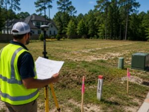
A Boundary Survey Can Find Easements You Cannot Easily See
An easement is a legal right that allows someone else to use a portion of a property for a specific purpose. Utility companies, neighboring landowners, or local governments may hold easements on a piece of land without anything on the surface to show it. There may be no markers, no signs, and no visible difference between the easement area and the rest of the lot.
A boundary survey connects what is recorded in official documents to what actually exists on the ground. Surveyors research the property records and mark where easements sit on the lot. That information gives homeowners a clear picture of which parts of the property have restrictions before any building plans get too far along to change.
Utility Easements May Change Where You Can Build
Utility companies often hold easements that run through residential lots. These easements give them the right to access underground pipes, power lines, or other equipment buried beneath the surface. Structures built over a utility easement can create serious problems. In many cases, the utility company has the legal right to remove anything sitting in their easement area to access their equipment, even if that means tearing out part of a new structure.
A boundary survey shows exactly where utility easements run and how wide they are. That information helps homeowners and builders decide where to place the house, where to put a garage, and where a driveway can safely go. Making those decisions before construction begins is far easier and less expensive than moving a structure after it has already been built.
Shared Driveways and Access Areas Can Affect Your Plans
Some properties carry easements that give neighboring landowners the right to cross part of the lot. A shared driveway that connects two properties to a main road is a common example. A recorded access easement running along the edge of the lot may also exist to give a neighbor a path to their land.
These easements affect where a homeowner can build and how the lot can be laid out. A garage planned for one corner of the lot may sit directly in the path of a recorded access easement. A fence line that seems like a natural fit may block an access area that someone else has a legal right to use. A boundary survey identifies these areas early so the building plan can work around them from the start.
Old Property Records Can Make Easements Hard to Understand
Easements recorded decades ago can be difficult to track down and interpret. Older deeds sometimes describe easement locations using reference points that no longer exist, like a tree that was removed or a road that was relocated. The written description in the records may be hard to match to the current state of the land without professional help.
A boundary survey does the work of comparing old legal records to what is currently on the property. Surveyors are trained to read old deed language and translate it into a map that shows where each easement actually sits today. That process brings clarity to records that would otherwise take a homeowner hours to search through, with no guarantee of getting the location right.
Finding Easement Problems Early Can Save Time and Money
A building plan that doesn’t account for easements is likely to run into trouble. If a permit application includes a structure that sits inside a utility easement, the permit office may reject it. If construction begins before easements are identified, the builder may need to stop work, redesign the project, and resubmit for approval. All of that costs time and money.
Getting a boundary survey done before the building plans are finished avoids most of those situations. When easements are mapped out early, the architect or builder can design around them from the beginning. The permit application reflects the actual restrictions on the property, and the approval process moves more smoothly. A single survey at the start of the project can prevent weeks of delays and redesign costs later.
Frequently Asked Questions
What is a boundary survey?
A boundary survey shows the location of property lines and other features that may affect how the land can be used, including easements recorded in legal documents.
Can a boundary survey show easements?
Yes. A boundary survey identifies easements and shows where they are located on the property based on official records and field measurements.
Why do easements matter when building a new home?
Easements can limit where a house, garage, driveway, or other structures can legally be placed. Building inside an easement area can lead to permit problems or require the structure to be moved later.
Can utility easements affect where I build?
Yes. Utility easements give companies the right to access their equipment on the property. Structures built over those areas may need to be removed if the utility company needs to reach their lines or pipes.
When should I get a boundary survey?
Before finalizing building plans. Getting a boundary survey early gives homeowners the information they need to design around easements before permits are submitted or construction begins.
For a free land surveying quote, call us at (256) 585-6346 or send us a message by going here.
Posted in land surveying, land surveyor | Tagged cost of land surveying, estimating the cost of land surveying, land surveying cost, land surveying cost Madison
Land Surveying: Estimating the Cost

Copyright (c) 123RF Stock Photos
Land surveying, in short, is the science and art of establishing or re-establishing property corners, property lines and/or boundaries. There are different reasons why someone wants a lot surveyed.
Essentially the most common is to check if a piece of land is vulnerable to flooding, to subdivide a property to sell or deed to family members as well as to determine if there are any encroachments. This may happen if a neighbour disputes that you are using a piece of his lot or viceversa (for more on this, go here).
The Cost of Land Surveying
If you need to have a piece of land surveyed, the first thing that will come to mind is “how much will it cost?”There are plenty of factors determining exactly how much land surveying for your land would cost.
The fact that this type of service must be carried out by an expert contributes a great deal to the overall cost of the service, but choosing a non-professional to survey your land is dangerous and possibly illegal for the non-professional. Because of this you have to take a good look around before settling with a surveying company.
If you must work within a particular budget, discuss this with the surveyor up-front. Very often he may be able to offer cost saving steps to get the work you need done within these cost limits. The form of the land must also be looked into. A square or even a rectangle piece of land is somewhat easier to survey than an odd shaped parcel, or one with many different sides.
With the latter, the surveyor would have to take more time in surveying the curves as well as the bends which means the cost of the service would go higher.
The overall measurements the land is also key factor here. Understand that the cost of land surveying is normally proportionate to the time and effort that the land surveyor would spend on the project. If the land that you’re having surveyed isn’t accessible, or has thick vegetation, then the total price of the survey might go higher.
This is true of the varying weather conditions that might impact the work. Surveying in warm weather is somewhat slower to keep from putting the crew members in danger. Also, most surveying can’t be done in the rain.
When requesting for an estimate, bear in mind that surveyors base the estimate on expected conditions at the site. These conditions could change, bringing about additional costs. Always ask about these potential additional cost scenarios.
All that being said, competitive prices are also to be expected, this is why we recommend deciding on a surveyor based upon his experience and reputation rather than on the price he writes on a piece of paper. Usually it is better to invest a good amount of money on a survey that’s well-done rather than choose a company with a very “affordable” price but have the survey repeated because the results were wrong.
To sum it up, you should always discuss the expenses of the survey before you decide to ask the surveyor to start his work. It’s also wise to receive a contract that lets you know what is expected of the land surveyor. This is one of the most important steps in getting your land surveyed.
For a free land surveying quote, call us at (256) 585-6346 or send us a message by going here.
Posted in land surveying, land surveyor | Tagged cost of land surveying, estimating the cost of land surveying, land surveying cost, land surveying cost Madison