
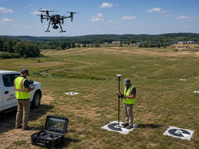
Drone land surveying helps engineers, developers, and property owners collect accurate site data across large areas quickly and efficiently. By capturing aerial imagery and elevation information, drone land surveying supports planning, design, earthwork calculations, and site development before construction begins.
Large properties can take days or even weeks to survey using traditional field methods alone. Drone technology allows surveyors to gather detailed information in a fraction of the time, while field crews verify boundaries, control points, and other features that require ground measurements.
How Does Drone Land Surveying Work?
Most survey drones carry a camera, not a laser. The drone flies a preprogrammed grid over the site and shoots hundreds or thousands of overlapping photos, capturing every point on the ground from several angles.
Software then does something remarkable. It finds the same physical feature across multiple photos, works out the geometry, and calculates a three-dimensional position for it. Repeat that across millions of matched features and you get a dense point cloud plus a stitched aerial image of the whole site. The process is called photogrammetry.
Ground control ties it all to reality. The crew places marked targets around the site and surveys each one with conventional equipment. Those known coordinates anchor the model, and without them the whole thing floats.
A smaller number of drones carry LiDAR sensors instead, which measure distance with laser pulses. Those cost considerably more and behave differently, which matters enormously on vegetated sites.
What Are the Benefits of Drone Land Surveying for Large Sites?
Speed is the obvious one. A flight covering 100 acres finishes in an afternoon. A crew walking the same ground with a rod spends a week, and the drone collects vastly more detail while doing it.
Cost follows from speed, since survey work gets priced largely in field hours.
Safety deserves mention too. Steep slopes, active quarries, landfills, stockpiles and construction sites all put crews in genuinely risky spots. A drone flies over them.
But the underrated benefit is the imagery. Photogrammetry produces an orthomosaic, which is an aerial photo corrected so you can measure distances directly off it. Every stakeholder on the project can look at the same picture and see the actual site rather than a line drawing. That changes conversations. A developer, an engineer and a lender all understand a photo instantly, and none of them have to interpret contours.
Repeat flights make the imagery even more useful. Fly monthly during construction and you get a visual record of progress, plus the ability to measure how much material moved between flights.
How Does Drone Land Surveying Improve Site Planning?
Planning decisions get made early, when nobody wants to spend money on data. That’s exactly the problem, because early decisions are the expensive ones.
Drone land surveying breaks that trade-off. It’s cheap enough and fast enough to run before the layout is locked, which means the design team can test ideas against the actual ground instead of an assumption.
Concrete uses at the planning stage:
- Comparing two or three layouts against real terrain before committing
- Rough earthwork estimates while the pad locations can still move
- Spotting drainage paths, low ground and off-site runoff entering the property
- Measuring stockpile volumes on an existing site
- Documenting conditions before a single machine touches the dirt
That last one protects you. A dated aerial record of the site as it existed before work began settles more disputes than anyone expects.
What Are the Limitations of Drone Land Surveying?
Photogrammetry has one hard limit, and understanding it prevents most bad outcomes.
A camera cannot see through anything. LiDAR pulses can slip through gaps in a tree canopy and reach the dirt below. A photograph cannot. If the camera sees leaves, the model gets leaves, and the resulting surface sits at the top of the vegetation rather than on the ground.
So a photogrammetric survey of a wooded parcel produces terrain that is confidently, smoothly, completely wrong. It looks fine. It’s off by however tall the trees are.
Grass and brush cause a milder version of the same error. Even a field of tall grass can lift the modeled surface by a foot.
Other real constraints:
- Water reflects and moves, so it maps poorly or not at all
- Wind, rain and low light degrade or cancel flights
- Airspace rules restrict flying near airports and over some areas
- Accuracy collapses without proper ground control, no matter how good the drone is
None of this makes drones bad. It makes them a tool with a shape, and open ground is the shape they fit.
When Should Drone Land Surveying Be Combined With Ground Surveys?
Nearly always, and the division of labor is clean.
The drone covers open terrain, broad elevations and imagery. The crew handles everything the camera can’t do: recovering property monuments, setting and measuring ground control, collecting pipe inverts inside culverts, picking up utility structures hidden in grass, shooting exact building and wall corners, and verifying the model with independent checkpoints.
Wooded areas fall to the crew as well, or to LiDAR if the budget allows.
And boundary work belongs entirely to a licensed surveyor. No drone, no camera and no software determines a property line. That requires deed research, monument recovery and professional judgment, and it always will.
The strongest arrangement puts one licensed surveyor over the whole package, responsible for the flight, the control, the ground work and the final product. Split it across vendors and the seams become your problem.
Frequently Asked Questions
Is Drone Land Surveying Accurate?
On open ground with proper control, yes, and often accurate enough for design work. Accuracy depends almost entirely on ground control and site conditions rather than on the drone itself. Over vegetation, accuracy drops sharply, since the camera measures the top of the plants instead of the soil.
Can Drone Land Surveying Replace Traditional Surveys?
No. It replaces a large share of the walking, which is where the savings come from. Boundaries, monuments, hidden features and verification all still require a crew, and boundary determination requires a licensed surveyor regardless of what technology collected the data.
How Large an Area Can Drone Land Surveying Cover?
A typical survey drone covers tens of acres to a few hundred in a day, depending on the flight height and the detail required. Larger areas mean multiple flights or a fixed-wing aircraft, and processing time grows along with the data.
What Data Does Drone Land Surveying Collect?
Overlapping photos, which become a point cloud, a terrain surface, contours and a measurable aerial image. Some drones carry LiDAR instead and collect laser measurements directly, which performs far better under tree cover.
Who Should Use Drone Land Surveying?
Developers, engineers, contractors and owners working with large, mostly open sites get the most value. It’s less useful on small lots, where a crew simply arrives and finishes, and on heavily wooded parcels, where the camera can’t see the ground at all.