Flood Elevation Certificate for Critical Equipment Relocation
Posted on September 10, 2026 by Madison Surveyor
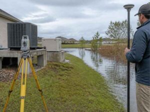
Moving a generator, an electrical panel, or an HVAC unit might seem like a simple job. But if the equipment sits in a flood zone, the move can affect your flood elevation certificate. Getting it wrong can cost more than the move itself.
A flood elevation certificate records the exact height of key parts of a building. It also records key equipment in some cases. When critical equipment moves, this record often needs to move with it.
This article covers what to check before, during, and after an equipment relocation. This keeps your elevation certificate accurate. It also keeps your flood insurance correct.
Establishing Existing Elevations Before Equipment Is Moved
Before any equipment moves, you need a clear picture of where it sits now. This starts with surveyed elevations. It should not start with guesswork.
A licensed surveyor measures the current height of mechanical and electrical equipment. This includes generators, HVAC units, and electrical panels. These are all tied to building operations.
These measurements become your baseline. Without them, you cannot know if a new spot is really an improvement. You also cannot know if it is a step backward.
This step matters in Madison. Flood zones and drainage can shift block by block. A building may look safe on a general flood map. But once real survey data comes in, it may sit close to a flood limit.
Why Guesswork Does Not Work Here
Some owners assume equipment sits high enough just by looking at it. A survey replaces that guess with a real number. That number ties back to a known reference point.
Required Flood Elevations That Affect the New Equipment Location
Once you know where equipment sits now, the next step is clear. You need to know where it should sit after the move.
A few numbers matter here. Base flood elevation, often called BFE, sets the flood level expected during a major storm. Finished floor elevation shows how high the main floor sits above that flood level.
Local floodplain rules can add more requirements on top of these numbers. Some cities require critical equipment to sit above BFE by a set amount. It is not enough to sit right at that level.
Check these points before you choose a new spot for equipment:
- Current base flood elevation for the property
- Any local rule requiring extra height above BFE
- Finished floor elevation of the building
- Whether local rules treat the equipment as critical
Skipping this step can lead to a move that looks complete. But it may not meet the elevation the property actually needs.
Why This Step Should Happen Before Design Work Begins
Contractors and engineers need these numbers early. If they design a platform without confirmed elevation data, they often have to redo the work later. That costs time and money.
Equipment Pads, Platforms, and Enclosures Need Accurate Elevation Data
Many equipment moves involve building something new. This might be a raised pad, a platform, or a protective wall. Each one needs real elevation data. General assumptions are not enough.
A pad built a few inches too low defeats the purpose of the move. A platform built without checked elevation data may look right on paper. It can still fail an inspection once someone checks the real numbers.
Surveyors give the reference points needed to build these structures the right way. This includes marking the required top height for a pad before construction starts. It should not happen after the work is done.
Protective walls around equipment also depend on this data. If the wall height comes from the wrong starting point, it may not protect the equipment during a flood.
Why Coordination With Engineers Matters
Engineers design the pad or platform. Surveyors confirm the elevation. Both groups need to work from the same numbers. If they do not, the finished structure may miss its goal.
Relocation Work Can Change Flood Compliance Documentation
Moving critical equipment changes more than the physical site. It can also change what needs to appear on your flood elevation certificate.
An elevation certificate records specific height points on a property. In some cases, this includes certain equipment heights. If equipment moves to a new height or spot, the certificate may need an update. This keeps the record accurate.
This matters for a few reasons. Lenders and insurers use the certificate to judge flood risk. If the certificate does not match current conditions, it can cause problems. This might show up during a policy renewal or a future sale.
Local floodplain offices may also require updated paperwork before they close out a permit. This is common for commercial or city projects.
Rules on when a certificate needs an update can vary. This depends on the city, county, and property type. If your project affects flood zone rules, check with your local floodplain office early.
Final Elevation Verification Before Project Closeout
Once equipment sits in its new spot, one step remains. You need to confirm the final height matches the plan.
A surveyor measures the finished installation. Then the surveyor compares it against the required elevation. This final check catches any gap between the design and the real construction. Gaps like this can happen even on a well-run project.
This step protects several groups. Property owners get proof that their investment meets flood rules. Engineers get a record showing the work matched the design. Insurers and local officials get accurate data for future flood risk reviews.
Skipping this step leaves a property with a guess instead of a proven record. If a flood happens later, that gap can matter. It can affect both safety and insurance claims.
Confirm your survey and paperwork needs early in the project. This keeps your flood elevation certificate accurate. It also helps you avoid delays during permit closeout or insurance review.
Frequently Asked Questions
Does moving equipment always require an Elevation Certificate update?
Not always. It depends on what moved, where it moved to, and local floodplain rules. Check with your surveyor and local floodplain office to confirm.
Who typically needs the updated elevation data after a relocation?
Lenders, insurers, and local floodplain offices often rely on this data. Property owners and engineers use it for compliance and future planning too.
What happens if equipment is installed below the required flood elevation?
This can create insurance and compliance problems. A final elevation check helps catch this issue before the project closes out, while it can still be fixed.
For a free land surveying quote, call us at (256) 585-6346 or send us a message by going here.
Posted in land surveying, land surveyor | Tagged Elevation Certificate